The remote and arid Kufrah district in Libya lies on top of one of the largest irrigation projects in the world.
The remote Kufrah district in southern Libya sits at the heart of the Sahara Desert. Filled with sand dunes and rugged plateaus, much of the district is extremely arid. But it wasn’t always so dry. Buried beneath the shifting sand dunes is a vast fossil aquifer and remnants of now-dried rivers.
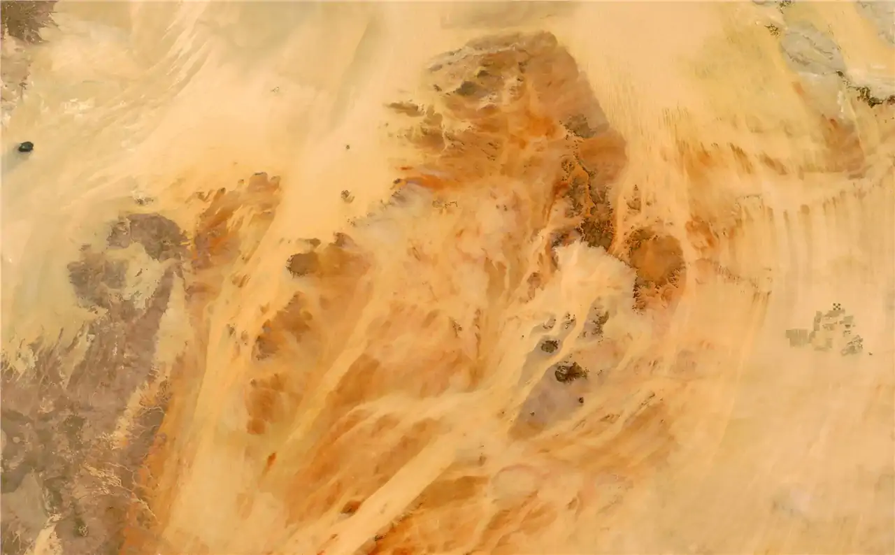
On May 26, 2022, the MODIS (Moderate Resolution Imaging Spectroradiometer) on NASA’s Terra satellite acquired this image of the Kufrah district. It is the largest and least populated district in the country. In the upper left of the image, a sea of unconsolidated sand, the Ribiana (Rabyanah) Sand Sea, meets plateaus on the northern edge of the Tibesti Mountains.
The arid region is mostly free of vegetation, except for a cluster of green visible in the upper right of the image. Most of this vegetation is farmland within the city of Al Jawf. The patterns of the farms give clues for how they are irrigated.
The photo below, taken by an astronaut on the International Space Station on October 22, 2016, shows farms with different irrigation patterns in Al Jawf. In the upper left of the image, the gridded farms likely use the furrow irrigation method, in which water is pumped into evenly spaced trenches between rows of crops. The circular fields likely use a center pivot method: water is pumped from a well in the center of the circle and distributed through a pipe hundreds of yards long, pivoting around a central point.

Photo of Al Jawf, captured by an astronaut aboard the International Space Station on October 22, 2016, shows farms with different irrigation patterns.
The water used for irrigation here is pumped from a large underground aquifer, called the Nubian Sandstone Aquifer. The vast reservoir lies under much of the Kufrah district, and contains fossil water that percolated into the region’s sandstone anywhere from 10,000 to 1,000,000 years ago, when the region received more rainfall and had a more temperate climate.
Evidence of this wetter time is apparent in digital elevation data from Landsat and NASA’s Shuttle Radar Topography Mission (SRTM). Scientists have used this data to map a large system of paleo-rivers that once crossed the district. Today, the district has no permanent rivers and lakes and only receives only about one millimeter of rain each year.
Underground pipes take fossil water from the sandstone aquifer to more populated cities along Libya’s Mediterranean coast. Known as the Great Man-Made River, the network of pipes is considered one of the largest irrigation projects in the world and was constructed in the 1980s and 1990s to bring water from the aquifer to large cities including Tripoli and Benghazi. By one estimate, the Great Man-Made River supplies 70 percent of all the water consumed in Libya.
NASA Earth Observatory image by Lauren Dauphin, using MODIS data from NASA EOSDIS LANCE and GIBS/Worldview. Astronaut photograph ISS049-E-43349 was acquired on October 22, 2016, with a Nikon D4 digital camera using a focal length of 1150 millimeters. The image was provided by the ISS Crew Earth Observations Facility and the Earth Science and Remote Sensing Unit at Johnson Space Center. The image was taken by a member of the Expedition 49 crew. It has been cropped and enhanced to improve contrast, and lens artifacts have been removed. The International Space Station Program supports the laboratory as part of the ISS National Lab to help astronauts take pictures of Earth that will be of the greatest value to scientists and the public and to make those images freely available on the Internet. Additional images taken by astronauts and cosmonauts can be viewed at the NASA/JSC Gateway to Astronaut Photography of Earth.